Skip to content

Walk, Explore and Discover

+977 9800000000

Direct call or whatsapp 24/7

Walk, Explore and Discover

+977 9851335885

Direct call or whatsapp 24/7

Annapurna Circuit with Tilicho Lake Trek – 14 Days

Key Points

DestinationNepal
Duration14 Days
Max Altitude4,919 m
AccommodationKathmandu and Pokhara hotels; mountain teahouses during the trek
MealsAccording to the confirmed package; normally full board during trekking days
Group Size1-9 Pax
Best TimeMarch–May and October–November
RegionAnnapurna Region

Expedition Overview

The Annapurna Circuit with Tilicho Lake Trek combines two of the Annapurna region’s most rewarding objectives in one carefully structured journey: the remote shores of Tilicho Lake and the 5,416-metre Thorong La Pass. Beginning in the lower Marsyangdi Valley, the route climbs through forest, farming settlements and traditional stone villages before entering the dry, dramatic highlands around Manang.

Trip Highlights

  • Visit Tilicho Lake at approximately 4,919 m, one of Nepal’s most spectacular high-altitude lake settings
  • Cross Thorong La at 5,416 m, the highest point of the classic Annapurna Circuit
  • Experience the changing landscapes of the Marsyangdi and Kali Gandaki valleys
  • Walk through Chame, Pisang, Manang, Khangsar, Muktinath and traditional mountain communities
  • Observe Buddhist monasteries, mani walls, prayer flags and the shared Hindu–Buddhist heritage of Muktinath
  • Enjoy close views of Annapurna II, Annapurna III, Gangapurna, Tilicho Peak, Chulu and the Dhaulagiri range
  • Complete an acclimatization day in Manang before entering the Tilicho and Thorong La sectors
  • Descend through Mustang and the Kali Gandaki Valley to a comfortable recovery stay in Pokhara

Cost Includes

  • Applicable government taxes.
  • Company service charges.
  • Airport arrival transfer and scheduled ground transportation according to the confirmed itinerary.
  • Licensed English-speaking trekking guide and required support staff according to group size.
  • Annapurna Conservation Area Permit and applicable trekking-registration arrangements.
  • Teahouse accommodation during the trek and hotels in Kathmandu and Pokhara as specified.
  • Meals during trekking days according to the confirmed package.
  • Guide and staff insurance, wages, meals, accommodation and necessary equipment.
  • Basic group first-aid supplies and emergency coordination assistance.
  • Assistance with required route and permit documentation.
  • Daily trail briefings and route decisions coordinated by the guide.

Cost Excludes

  • Tips for guides, porters, drivers and support staff.
  • International flights.
  • Nepal visa fees.
  • International travel insurance covering high-altitude trekking and emergency evacuation.
  • Meals in Kathmandu and Pokhara unless specifically included in the quotation.
  • Personal beverages, snacks, hot showers, charging, Wi-Fi, laundry and lodge extras.
  • Personal trekking clothing, footwear, sleeping bag and equipment rental.
  • Costs caused by weather, road disruption, illness, evacuation, itinerary changes or circumstances beyond company control.
  • Any service not specifically listed under Cost Includes.
  • Emergency medical treatment or helicopter rescue costs.
  • Personal clothing and trekking footwear.
  • Personal trekking equipment or optional gear hire.

Day-by-Day Route Itinerary

Day 1

Arrival in Kathmandu and Trek Preparation

DestinationKathmandu
End altitude1,350 m

transfer Arrive at Tribhuvan International Airport, meet the Barunche representative and transfer to your Kathmandu hotel. After time to rest, attend a detailed trek briefing covering the route, altitude profile, road journey, Tilicho Lake conditions and Thorong La crossing. The guide checks insurance details, emergency contacts, medication and essential equipment. Any missing trekking items can be arranged in Kathmandu, and the evening is kept relaxed before the early overland departure.

AccommodationHotel in Kathmandu
Day 2

Drive from Kathmandu to Dharapani

Duration: Approximately 9–11 hours, depending on road conditions
FromKathmandu
ToDharapani
Start altitude1,350 m
End altitude1,860 m

Leave Kathmandu early and follow the highway west before turning north toward the Marsyangdi Valley. The scenery changes from urban outskirts to terraced hillsides, river gorges, waterfalls and roadside settlements as the journey approaches the Annapurna region. The final mountain-road sections may be rough, dusty or affected by seasonal maintenance. On arrival in Dharapani, check into the lodge, reorganize the daypack and receive a briefing for the first walking stage.

AccommodationTeahouse in Dharapani
MealsBreakfast, lunch and dinner
TransportRoad transfer
Day 3

Trek from Dharapani to Chame

Duration: Approximately 5–6 hours
FromDharapani
ToChame
Start altitude1,860 m
End altitude2,670 m

Begin trekking through pine and fir forest, crossing streams and passing settlements influenced by Tibetan Buddhist culture. The route gains height steadily, with improving views toward Annapurna II and the surrounding ridges. Short breaks support hydration and a sustainable rhythm. Chame, the administrative centre of Manang District, offers a comfortable overnight stop where the guide reviews the next day’s longer approach toward Pisang.

AccommodationTeahouse in Chame
MealsBreakfast, lunch and dinner
Day 4

Trek from Chame to Upper Pisang

Duration: Approximately 5–6 hours
FromChame
ToUpper Pisang
Start altitude2,670 m
End altitude3,300 m

Follow the Marsyangdi through forest and beneath the immense curved rock face of Paungda Danda. As elevation increases, the valley opens and the vegetation becomes noticeably drier, revealing broader views of Annapurna II and Pisang Peak. A steady pace is important as the sleeping altitude rises above 3,000 metres. Upper Pisang provides traditional architecture, monastery surroundings and a strong vantage point for the next stage toward Manang.

AccommodationTeahouse in Upper Pisang
MealsBreakfast, lunch and dinner
Day 5

Trek from Upper Pisang to Manang via Ngawal

Duration: Approximately 7–8 hours
FromUpper Pisang
ToManang
Start altitude3,300 m
End altitude3,540 m

Take the higher route through Ghyaru and Ngawal for outstanding views across the Annapurna massif. The trail climbs steeply in places, passes dry fields, mani walls and traditional villages, and offers a valuable acclimatization benefit before descending toward the main valley. Continue through the broad upper Marsyangdi landscape to Manang. The guide checks appetite, hydration, headache and energy levels on arrival, as the following day is reserved for acclimatization rather than immediate further ascent.

AccommodationTeahouse in Manang
MealsBreakfast, lunch and dinner
Day 6

Acclimatization Day in Manang

Duration: Approximately 3–5 hours of optional acclimatization walking
FromManang
ToManang
Start altitude3,540 m
End altitude3,540 m

walk Use the day to support adaptation with a controlled walk toward a suitable viewpoint such as Gangapurna Lake, the surrounding ridge or another route selected by the guide. The objective is moderate elevation gain followed by a return to Manang’s lower sleeping altitude. The afternoon is reserved for rest, hydration and preparation for Tilicho Lake. The guide conducts a health review and explains altitude symptoms, cold exposure, the landslide-prone sections beyond Khangsar and the importance of keeping a flexible mountain schedule.

AccommodationTeahouse in Manang
MealsBreakfast, lunch and dinner
Day 7

Trek from Manang to Khangsar

Duration: Approximately 3–4 hours
FromManang
ToKhangsar
Start altitude3,540 m
End altitude3,750 m

Leave the main Annapurna Circuit trail and follow the Tilicho side valley toward Khangsar. The shorter walking day allows continued acclimatization while the scenery becomes more isolated beneath Gangapurna, Tilicho Peak and the surrounding high ridges. After reaching Khangsar, settle into the lodge and prepare for the more exposed trail to Tilicho Base Camp. The guide reviews weather, trail reports and safe group spacing for loose or landslide-affected sections.

AccommodationTeahouse in Khangsar
MealsBreakfast, lunch and dinner
Day 8

Trek from Khangsar to Tilicho Base Camp

Duration: Approximately 5–6 hours
FromKhangsar
ToTilicho Base Camp
Start altitude3,750 m
End altitude4,150 m

Continue through increasingly barren alpine terrain toward Tilicho Base Camp. Parts of the trail cross steep, loose slopes where stonefall and erosion can affect the route, so the group follows the guide’s spacing and does not stop unnecessarily in exposed areas. The final approach reaches the base-camp lodge beneath a dramatic wall of peaks. Rest, warm fluids and an early dinner are prioritized because the lake excursion begins before sunrise when conditions are generally calmer.

AccommodationTeahouse at Tilicho Base Camp
MealsBreakfast, lunch and dinner
Day 9

Hike to Tilicho Lake and Return to Tilicho Base Camp

Duration: Approximately 7–9 hours
DestinationTilicho Base Camp
End altitude4,919 m

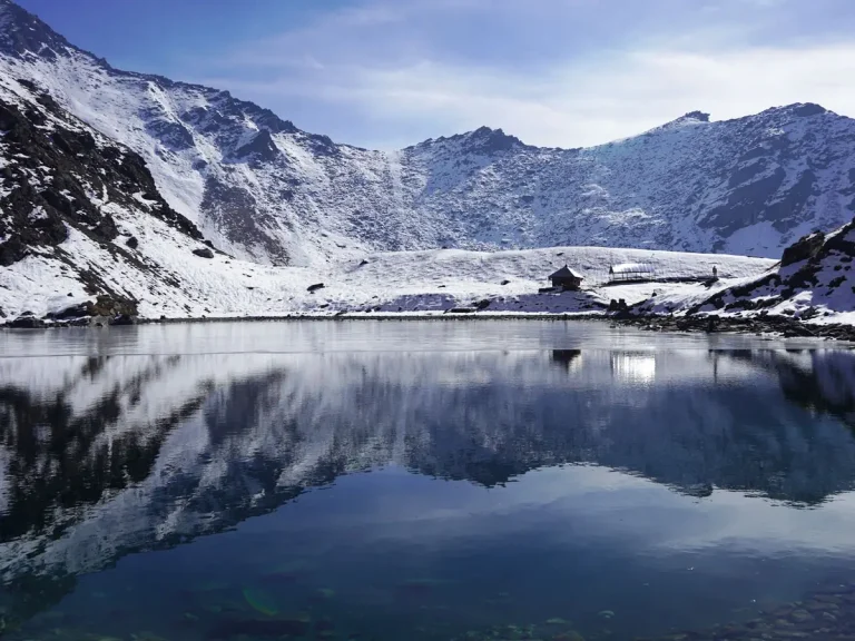
return Start early and climb gradually across cold, open terrain toward Tilicho Lake. The high altitude makes even a steady gradient demanding, and the guide controls the pace while monitoring breathing, coordination and symptoms of altitude illness. Reach the turquoise lake when weather and individual condition permit, with impressive views toward Tilicho Peak and the surrounding snow slopes. After sufficient time for photographs and appreciation of the landscape, descend carefully to base camp for food, hydration and recovery.

AccommodationTeahouse at Tilicho Base Camp
MealsBreakfast, lunch and dinner
Day 10

Trek from Tilicho Base Camp to Yak Kharka

Duration: Approximately 6–7 hours
FromTilicho Base Camp
ToYak Kharka
End altitude4,050 m

Retrace the exposed sections toward Khangsar before taking the connecting trail back to the Annapurna Circuit. The day includes varied ascent and descent through dry alpine terrain, with views across the Manang Valley and surrounding peaks. Continue toward Yak Kharka at a measured pace. The overnight elevation is slightly lower than Tilicho Lake, supporting recovery before the approach to Thorong Phedi, but the guide continues daily altitude monitoring.

AccommodationTeahouse in Yak Kharka
MealsBreakfast, lunch and dinner
Day 11

Trek from Yak Kharka to Thorong Phedi

Duration: Approximately 4–5 hours
FromYak Kharka
ToThorong Phedi
Start altitude4,050 m
End altitude4,540 m

Follow the high valley toward Thorong Phedi, crossing the river and negotiating sections where rockfall or trail erosion may require caution. The distance is moderate, but the elevation demands slow movement and regular breathing breaks. Arrive early enough to rest, hydrate and prepare clothing, headlamps, water and snacks for the pass crossing. The guide reviews the forecast, group health and turnaround policy before confirming the pre-dawn departure.

AccommodationTeahouse at Thorong Phedi
MealsBreakfast, lunch and dinner
Day 12

Cross Thorong La and Descend to Muktinath

Duration: Approximately 8–10 hours
FromCross Thorong La and Descend
ToMuktinath
End altitude3,762 m

Begin before sunrise and climb slowly toward Thorong La, using headlamps until daylight. Snow, wind and cold can make the crossing significantly harder, and the guide maintains a conservative pace with regular checks for fatigue and altitude symptoms. Reach the prayer-flag-covered pass when conditions permit, then descend carefully on the western side. The long loss of elevation leads into the dry Mustang landscape and finally Muktinath, where a warm meal and thorough recovery are priorities.

AccommodationTeahouse in Muktinath
MealsBreakfast, lunch and dinner
Day 13

Drive from Muktinath to Pokhara

Duration: Approximately 9–11 hours, depending on road conditions
FromMuktinath
ToPokhara
Start altitude3,762 m
End altitude822 m

Leave Muktinath after breakfast and travel south through the arid Mustang landscape, passing settlements along the Kali Gandaki corridor. The road then descends through changing ecological zones toward Beni and continues to Pokhara. Views, road surfaces and travel speed vary considerably between high mountain sections and the lower valley. This is a long transfer day, and landslides, construction, traffic or seasonal road damage can extend the journey. On arrival in Pokhara, check into the hotel, enjoy a hot shower and use the evening for recovery after the Tilicho Lake and Thorong La stages.

AccommodationHotel in Pokhara
TransportRoad transfer
Day 14

Return from Pokhara to Kathmandu

Duration: Approximately 25 minutes by flight or 7–9 hours by road
FromReturn from Pokhara
ToKathmandu
End altitude1,350 m

Return to Kathmandu using the transportation specified in the confirmed package. A domestic flight provides the shortest option but remains subject to weather and operational changes; the road journey follows the Prithvi Highway through river valleys, hill towns and busy approach roads to the capital. After arrival, transfer to the hotel or agreed drop-off point. Travellers should keep sufficient buffer time before an international flight because mountain roads and domestic aviation can be delayed. The 14-day program concludes in Kathmandu after completing Tilicho Lake and Thorong La.

AccommodationHotel in Kathmandu when included
TransportFlight

Essential Packing lists

Main Trekking Gear5
Daypack / Backpack (30–40L)Comfortable daypack with rain cover for water, layers, camera and daily essentials.
Duffel Bag (60–80L)For porter or luggage transport on multi-day trips where applicable.
Warm Sleeping BagTemperature rating should match the season and maximum sleeping altitude.
Trekking PolesUseful for long descents, uneven trails and reducing knee strain.
Water Bottles / Hydration System (2L+)Carry enough refillable capacity for the day.
Clothing – Layering System7
Moisture-Wicking Base LayersQuick-dry tops and bottoms; avoid cotton for cold/high-altitude trekking.
Fleece / Mid LayerWarm breathable layer for mornings, evenings and cooler trail sections.
Insulated Down / Synthetic JacketWarm outer insulation suitable for the season and altitude.
Waterproof / Windproof ShellLightweight hooded jacket for rain, snow and strong wind.
Trekking Pants / Hiking TrousersComfortable quick-dry trousers plus a warmer option for colder trips.
Thermal BottomsUseful for cold evenings, high camps and winter trips.
Trekking SocksSeveral pairs of moisture-wicking trekking socks plus warm socks.
Headwear & Handwear4
Sun Hat / CapFor strong daytime sun and UV exposure.
Warm BeanieWarm hat covering the ears for cold mornings and evenings.
Buff / Neck GaiterMulti-purpose protection from sun, dust, wind and cold.
Warm GlovesInsulated gloves; add waterproof outer gloves for winter/high altitude.
Footwear3
Trekking Boots (1 pair)Mostly waterproof and broken-in boots with ankle support.
Camp Shoes / Sandals (1 pair)Light footwear for lodges, camps and rest time.
GaitersRecommended for snow, mud, loose scree and winter conditions.
Toiletries & Hygiene5
Sunscreen SPF 50+High UV protection is important at altitude.
Lip Balm with SPFProtects lips from wind, cold and strong UV.
Hand Sanitizer / Biodegradable SoapCompact personal hygiene supplies.
Personal ToiletriesToothbrush, toothpaste and small personal hygiene items.
Toilet Paper / Wet WipesCarry a small personal supply and dispose responsibly.
Health & First Aid4
Personal MedicinesBring enough prescription medicine for the full trip plus reserve days.
Small Personal First-Aid KitBasic pain relief, bandages, antiseptic and common personal medicines.
Blister CareMoleskin, blister pads or similar foot-care supplies.
Water PurificationPurification tablets, drops or a reliable filter where needed.
Documents & Money4
Passport & VisaOriginal passport plus required visa documentation.
Travel Insurance DetailsCarry policy and emergency contact details; high-altitude cover when relevant.
Permit / ID CopiesKeep digital and paper copies of important travel documents.
Cash & Bank CardsRemote areas may have limited or unreliable ATM/card access.
Electronics & Accessories3
Headlamp + Spare BatteriesEssential for early starts, lodges and power cuts.
Power BankCharging can be limited or paid at remote lodges.
Phone / CameraProtect electronics from dust, rain and cold.
Optional but Recommended Items3
UV-Protected SunglassesStrong UV protection; glacier-rated lenses for snowy/high-altitude routes.
Personal Snacks / Energy BarsUseful for long walking days between meals.
Dry Bags / Zip BagsKeep electronics, documents and spare clothes dry and organized.
Essentials6
Layered base, insulation and waterproof clothing suitable for sub-zero conditions
Warm hat, sun hat, gloves and spare socks
Trekking poles, headlamp and spare batteries
Sunglasses, high-SPF sunscreen and lip protection
Daypack, duffel bag and waterproof pack covers
Microspikes or additional traction when seasonal conditions require them

What Makes This Trip Different?

Tilicho Lake and the Complete High-Pass Experience

This itinerary does more than follow the standard circuit. It includes the rewarding side route to Tilicho Lake while preserving the acclimatization and progressive altitude gain needed before Thorong La. Travellers experience glacial scenery, exposed alpine terrain, pilgrimage culture and two major Himalayan objectives in one continuous journey.

Local Communities and Responsible Mountain Travel

The trek supports locally operated lodges and mountain communities across Lamjung, Manang, Mustang and Myagdi. Barunche Treks & Expeditions emphasizes respectful cultural encounters, careful waste management, safe drinking-water practices and realistic daily pacing rather than rushing through fragile high-altitude environments.

Permits and Entry Requirements

The route normally requires an Annapurna Conservation Area Permit and the trekking registration required under current Nepal regulations. Permit arrangements can change, so Barunche Treks & Expeditions confirms the applicable requirements before departure.

The program uses road transportation to Dharapani, local mountain-road transport in Mustang and a flight or road transfer from Pokhara to Kathmandu according to the confirmed package. All journey times are approximate and remain subject to weather, traffic and road conditions.

Best Season, Weather and Temperature

The most dependable general seasons are spring from March to May and autumn from October to November. Autumn often provides stable visibility and dry trails, while spring brings warmer conditions and flowering forests at lower elevations. Snow can affect Tilicho Lake and Thorong La in any season, and monsoon rain may cause landslides and road disruption.

US$ 1,400 PP
Save 20% US$ 350 per person
Regular:US$ 1,750
Group range:US$ 1,400 - US$ 1,750
Duration:14 Days

Group-Size Discounts

Pricing is based on your group size. We do not add others to your group.

No. of PersonsGroup TypePrice per Person
1 Pax US$ 1,750 Book
2-3 Pax US$ 1,550 Book
4-9 Pax US$ 1,400 Book
Dates & discounts are applied in the next step.

Guides and Porters

An experienced trekking guide accompanies the group, coordinates route decisions and accommodation, and monitors the day’s conditions and group wellbeing. Travelers should follow the guide’s instructions at exposed trails, river crossings and high-altitude sections.

Translate »